
New
#1
Wow 15 years ago, I remember that. And now I use it daily for work.
Since it launched 15 years ago, Google Maps has redefined what it means to be a mapevolving from a powerful navigational tool to a robust daily companion that also offers helpful information about where to go and what to do. Features like popular times, multimodal navigation, and offline maps help you better understand your world so you can decide how to interact with it.
This week, were rolling out new visual improvements that bring even more detail and granularity to the map, making it easier to understand what an area looks like whether youre exploring virtually or planning a visit.
A more colorful and accurate view of the world 🌎
Google Maps has high-definition satellite imagery for over 98 percent of the worlds population. With a new color-mapping algorithmic technique, were able to take this imagery and translate it into an even more comprehensive, vibrant map of an area at global scale. Exploring a place gives you a look at its natural featuresso you can easily distinguish tan, arid beaches and deserts from blue lakes, rivers, oceans and ravines. You can know at a glance how lush and green a place is with vegetation, and even see if there are snow caps on the peaks of mountaintops.
With this update, Google Maps has one of the most comprehensive views of natural features on any major map appwith availability in all 220 countries and territories that Google Maps supports. Thats coverage for over 100M square kilometers of land, or 18 billion football fields!
This update is visible no matter what area youre looking atfrom the biggest metropolitan areas to small, rural towns.
Mapping the rainbow 🌈
How exactly does this color-mapping technique work? First, we use computer vision to identify natural features from our satellite imagery, looking specifically at arid, icy, forested, and mountainous regions. We then analyze these features and assign them a range of colors on the HSV color model. For example, a densely covered forest can be classified as dark green, while an area of patchy shrubs could appear as a lighter shade of green.
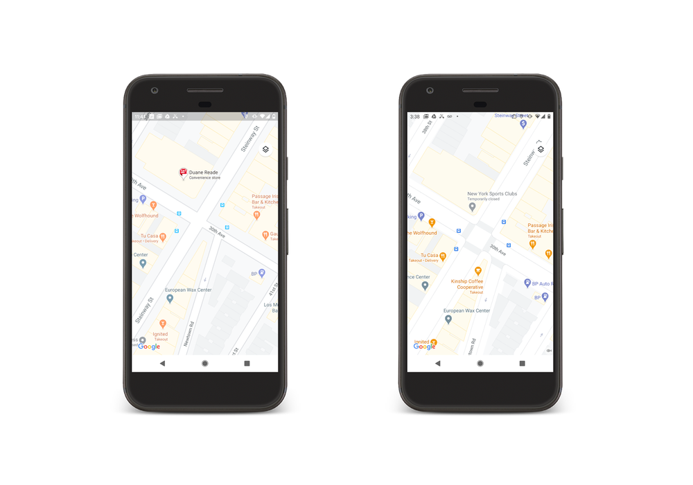
More detail when youre on the go 🚶🏽*♀️
While seeing natural features can help you get a feel for an area, sometimes you need more information to get around safely and efficiently. Soon, youll be able to see highly detailed street information that shows the accurate shape and width of a road to scale. You can also see exactly where sidewalks, crosswalks, and pedestrian islands are locatedcrucial information if you have accessibility needs, like wheelchair or stroller requirements. These details are particularly helpful as more people are opting to walk or take other forms of solo transportation due to the pandemic. Well start rolling out detailed street maps in London, New York, and San Francisco in the coming months, with plans to expand to more cities over time.
View crosswalks, sidewalks, and pedestrian islands right from Google Maps. You can also see the shape and width of roads.
Whether youre exploring a new place or gearing up to head around town, you can use Google Maps to see a more colorful, easy-to-understand representation of the world starting this week. To see natural features, zoom out on Google Maps. And if youre a Google Maps Platform developer, youll soon be able to apply this new styling to your maps.
Source: A more detailed, colorful map
Brilliant web site including Street View. Haven't seen the imprved colour yet in the UK. Note also Google Sky and Google Earth.
Hi there
Doesn't the U.S Army now use Google Maps because its more accurate than theirs !!!!
Anybody remember seeing that stunning TV newscast from the ist gulf war of a Cruise missile being filmed by a CNN journalist in IRAQ going down a main road and turning left at a set of traffic signals (obeying the Green light !!) -- navigated by Google Maps I think even back then !!
Cheers
jimbo

 Quote
Quote